At PhytoMaps we track turf health with two tools: satellite imagery and multispectral drone imagery. We are often asked which one is better. In our experience, that is the wrong question. The two are built for different jobs, and they are at their best when you use them together. In late May 2026, a real golf course gave us a clear way to show this. (We explain the trade-offs in more depth in our guide to satellite and drone turf monitoring.)
How we tested it
At Land-Golf-Club Schloss Moyland in Kleve, Germany, a satellite passed over the course on 26 May. Three days later, on 29 May, we flew a multispectral drone over the same ground. We scored every green and every fairway using the exact same boundaries for both tools, 38 areas in total. That is what makes this a fair comparison: both instruments measured the same shapes, so we could line the results up side by side.
Both tools measure the same thing in different ways. Each uses vegetation indices to gauge how green, dense and healthy the turf is. The difference is distance and timing. The question we set out to answer was simple: do satellite and drone tell the same story?
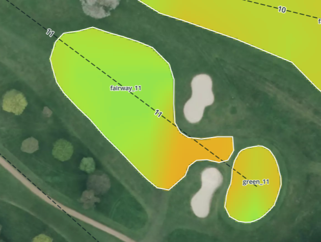 Satellite
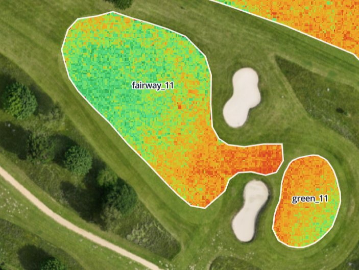 Drone
DroneWhere they agreed: the fairways
Fairways are large, so each tool has plenty of surface to measure. Here the results lined up closely. When the satellite and the drone each ranked the fairways from healthiest to weakest on their own, the two lists came out in nearly the same order, about 8 times out of 10. The same fairway came top in both rankings, and they matched on five of the top six places. For week-to-week monitoring of the whole course, that is a strong result. The satellite view and the drone view point the same way.
Where the detail changes: the greens
Greens are smaller, and that changes what each tool can measure. A single satellite pixel covers about a 10-metre square, roughly 100 square metres of ground. A fairway is large enough to fill dozens of these pixels, so it is measured in fine detail. A typical green on this course is only about 340 square metres. That gives the satellite about three pixels per green, and those few pixels also pick up the collar and the surrounds. With so little surface to measure, a small green is harder to grade precisely from space.
This is exactly where the drone is strong. Its centimetre-level imagery measures a small green in fine detail. So we use each tool for what it does best. On greens, the satellite score is flagged as lower confidence, so you always know how much weight to give it, and the drone or a quick walk provides the close-up confirmation.
One note on the numbers: the satellite and drone cameras report their greenness values on slightly different scales. So we compare patterns and rankings, who is up, who is down and what is changing, rather than matching raw numbers digit for digit. That is the right way to read any two instruments together.
What the day showed
Both tools agreed the course was in good health. There were no problem areas, scores ran from 86 to 97 out of 100, and neither tool raised a false alarm.
Alongside the imagery, the satellite layer also carries a weather-based disease forecast. In the warm, humid days before this visit, our model showed dollar spot pressure running high. That is an early warning that helps a greenkeeper decide where to scout or spray before symptoms show on the turf. It works hand in hand with what the team sees in the field and in the drone imagery.
Two tools, two strengths
The clearest way to think about satellite and drone turf monitoring is as a pair:
- Multispectral drone imagery gives centimetre-level detail on demand. It is ideal for greens, close inspections, and a precise record of conditions on a chosen date.
- Satellite imagery gives a fresh view of the whole course every few days, with no flight to plan, plus a weather-based disease forecast on top.
Used together, they cover more ground than either can alone. The satellite keeps a regular eye on the whole property, and the drone delivers fine detail wherever you want a closer look.
The bottom line
- On fairways and larger areas, satellite and drone agreed closely on this course, matching about 8 times out of 10 by ranking.
- On small greens, the drone's fine detail does the close work, while the satellite score is flagged as lower confidence.
- For golf course turf health, the strongest approach is not satellite or drone. It is satellite and drone, each doing the job it does best.
Want to see how a side-by-side comparison looks on your own course? Get in touch and we will walk you through it.